By AMANDA SPOTTISWOODE
The following statement comes from the BC Parks website: “Inherent in this mandate is the requirement to maintain a balance between BC Parks’ goals for protecting natural environments and outdoor recreation.”
I’m not sure how the current work being undertaken in Burgoyne Bay as described in last week’s Driftwood fulfils the “outdoor recreation” part of the requirement, since a large part of the park has now become user unfriendly for walkers and equestrians.
Burgoyne Bay Park is one of the only places on the island that has officially sanctioned horse trails. A horse is clearly shown on the sign at the entrance to the main trail. It was a lovely easy circuit that we often rode, stopping for tea along the way and greeting and being greeted by other park users. Someone had better scratch the horse icon off the sign, as most of the trails are now impassable to horses.
The first indication that something was amiss for us horse lovers, was the “squeeze” gate installed at the entrance to the big field. Walkers and dogs could get through but it is just small enough to preclude horses from that part of the park. At this point I anticipate that there will be readers of this letter who point out that that part of the park is no longer designated a multi-use trail, which would include horses. I have studied the most recent trail maps posted around the park and technically that trail is now a “hiking” and not a “multi-use” trail. The point is that it always was a horse trail — one of the prettiest in the park with sweeping views of the valley and Mount Maxwell. There is no reason to exclude horses from this part of the park.
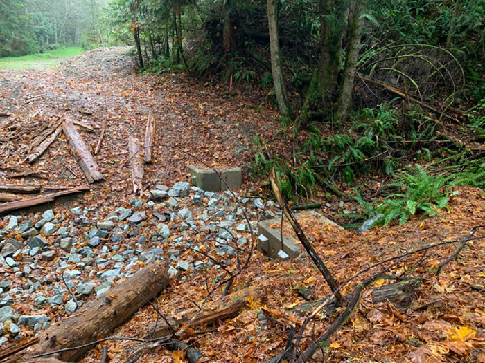
Next was the closure of the trail along the back of the park and the removal of the bridge. Walkers can, and will cross that creek with or without a bridge, but we on our horses cannot and I suspect that a lot of senior walkers will be deterred from scrambling down the bank and up the other side. In addition, the “swales” mentioned in last week’s article (I’d call them ditches) pose a serious hazard to those walkers who use walking poles and, you guessed it, horses. Just another reminder here that horses in the park are perfectly legal.
Those swales have also been dug on the trail that goes up the hill (a “multi-use” trail), which makes it useable only by those fit enough to jump over the soggy ground in the bottom of each swale. My horse sunk in one up to her fetlock. The swales reminded me of the state of the Fulford-Ganges Road, which is increasingly becoming a real roller coaster ride.
Finally, once you’ve crossed the bridgeless creek, the way into the back of the park has been blocked by a splendid new fence, again passable by walkers and dogs, but not by horses. The subject becomes a little murky here because to access the trail back into the park one has to “trespass” for about 200 metres on the property owned by the CRD and on which the sewage plant is located. According to my topographical trail app, the park boundary is inches to one side of the road and it would be perfectly possible to make a trail that stays within the park. Once past the first fence on the trail back down to the fields, there is a second fence with a completely erroneous sign declaring that if you pass the fence (going towards the CRD property) you are trespassing on “private property.” Again, I refer to my app that clearly shows the park boundary and shows that you are still well within the park for several hundred metres past the sign. And am I right in my supposition that CRD property is not “private” but owned by the regional district and therefore taxpayer funded?
I’m not an expert, but I think there must have been less extreme measures that would have had the same result in terms of preserving and protecting the park and improving habitat for various species. How about instead of the “swales” that culverts be installed to allow the passage of water under the trail and safe passage of hikers along the trail?
How about a new bridge that is designed in such a way as to not interfere with the creek flow? The current “improvements” will likely have an impact on the diversity of users that I have seen in the 25 years I’ve lived on Salt Spring. It will become a place for scientists and environmentalists to the exclusion of walkers and horse riders. Burgoyne has always been one of Salt Spring’s natural attractions for residents and visitors alike, but I suspect that the hidden agenda is to discourage these “ordinary” users.
In case it needs noting here, humans are also part of the eco-system and the availability of recreational areas for outdoor activities, such as hiking, walking your dog and horseback riding, is vital to the health and well being of us all. Oh, and perhaps some of the money being spent on these environmental upgrades would have been better directed towards cleaning up the beach, which is currently littered with abandoned boats and garbage, leaching who knows what pollutants into the bay.

